|

|

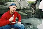
Basil Seggos of Riverkeeper
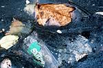
Pollution in the creek |
|
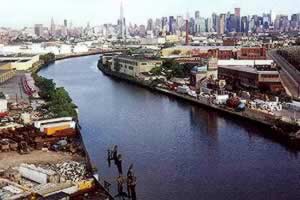
| When 30,000 marathon runners cross the Pulaski Bridge, the halfway point in the annual New York marathon, they will be running over the most polluted waterway in America. They might hold their nose, but they probably won't know the name of the water releasing the stench. "This is a waterway that most people don't even know exists," says Basil Seggos, lead investigator for the Riverkeeper organization, a not-for-profit environmental watchdog. "We wanted to put up a sign up, saying 'You Are Crossing Newtown Creek.' The city said no."
The
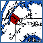
Newtown Creek is a murky estuary that runs 3 1/2 industrialized miles along
the border of Greenpoint, Brooklyn and Maspeth, Queens. Once a site of mansions,
then a mecca for shipbuilders, the creek is now a toxic dumping ground that bubbles
up raw sewage every time it rains. Newtown Creek has been given the lowest possible
cleanliness rating by both New York City and New York State. The Riverkeeper,
in their report last month, wrote of the creek:
"It fails to meet even the most basic goals of the 1972 Clean Water Act. Nearly the entire stretch of the creek is heavily industrialized, there is virtually no public access, and water dependent industries have stagnated. A boat trip up the creek is a journey into the heart of darkness, with the backdrop of the Manhattan skyline as a reminder of its real world locale."
East River Apprenticeshop
|
|
|
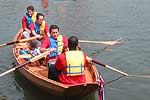
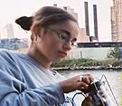
But
even the heart of darkness has a little light. On
the fifth floor of a converted factory on the water's edge, a boat-building
workshop echoes with the whine of power tools, the rhythm of scratching sandpaper,
and the guitar wails of one student's punk band blasting out of the CD
player. All the workers here are local high school students, and on the floor
lies the fruit of their labors — the bare outlines of a 22-foot oyster
boat that they will complete and launch into the creek this summer. On the wall
hangs a 4-color map of the creek — charted and drawn by the students last
summer. Welcome to the East
River Apprenticeshop, Newtown Creek's best hope for a new future.
Watch a video about Newtown Creek

We want to hear your thoughts on the issues. How do you relate to your environment? Do you know your local waterways as well as you know the roads? Share your story with us, and see what others have to say.
|
Related Links
Riverkeeper
East River Apprenticeshop
|
|
|
 |

Travel down the most polluted waterway in America,
Newtown Creek, located on the border between Brooklyn and Queens in New York
City, with the Riverkeeper captain and investigation team. Learn about the amazing
history
of the creek and meet the group of inner city kids who have reclaimed it as a
playground for their boat building and nature explorations. [7:49 minutes]
|
|
|
|
Mapping your waterway can give you a whole new way of seeing your community.
|
|
|
 |
 Trash-talking writer Elizabeth Royte explores the colorful story and impending fate of another polluted waterway, Brooklyn's Gowanus
Canal. Go Trash-talking writer Elizabeth Royte explores the colorful story and impending fate of another polluted waterway, Brooklyn's Gowanus
Canal. Go  |
|
|
 |
| In a world built for automobiles, it seems harder
than ever to stay in touch with water. Streams and creeks flow all around us,
all
but ignored by passing traffic. Waterways that are shielded by industry or
highways, without points of access and clearly marked signs, can be practically
invisible. We've collected the following links to help you explore and interact
with your local waterways. |
 | EPA: Surf Your Watershed
Search this comprehensive database to find your watershed. Watersheds cross state and national boundaries and can be hundreds of miles wide. Wherever you go - you're in a watershed. Kids, Teachers, Families: Be sure to check out the Surf Your Watershed's Kids page featuring games, activities and projects for all ages. |
| U.S. Geological Survey
Another great resource for learning about the condition of water in your state can be found at water.usgs.gov. The site features interactive maps, a network of real-time data, and classroom activities. |
| EPA: Monitoring & Assessing Water Quality
Do you know only one third of American waterways are regularly monitored by the EPA? That's why monitoring is so important - whether you're using spectrometers and microscopes, or just your eyes and nose.
But how do you monitor? The simplest way is to visit rivers near you. If you notice any odd smells, or see something floating that doesn't look like it belongs there, report it. Access how-to manuals and phone numbers at the EPA's volunteer monitoring page. Browse back issues of the Volunteer Monitor to find out what groups are doing in your area. |
|
|
|

Something happened to 13-year-old Theresa Ramos the summer she spent exploring
Newtown Creek. She went from failing her classes to being a star freshman
at the New York Harbor School. But it's not just Theresa's life that
turned around. How one girl's love of boats stopped a whole family from
sinking. (5:57 minutes).
|
|
|