Jump to:
Procedure | Extension
Ideas | Related Standards | Resources | PBS Resources
INTRODUCTION
A watershed is a drainage basin that includes a collection of smaller waterways and water bodies that flow in to a common major waterway or water body. Watersheds are based on topography and are important land distinctions as they determine where water flows along it's journey from precipitation to ocean. The study of water flow through watersheds is also a useful tool for ecologists as this flow carries pollutants, can dilute pollutants, shapes land and influences human activities. This lesson aims to connect students to their watershed by exploring a local water body and mapping its features.
GRADE LEVEL
This lesson plan is designed to be used with high school level students, but can be adapted to other grade levels. (See Extension Ideas).
SUBJECT AREAS
This lesson plan addresses concepts in Environmental Science/Ecology, Chemistry, Physics, Biology, Mathematics, and the Social Sciences.
OBJECTIVES
By the end of this lesson, students will:
• understand what a watershed is;
• have identified which watershed they are part of;
• understand what a topographic map is and how it is useful;
• have mapped a local water body; and
• will be able to identify/describe how that local water body fits in to the larger scheme of the watershed.
ESTIMATED TIME
Three full class periods, one being a field trip to the closest water body to the school.
MATERIALS
• Computer with Internet access
• Topographic map of your local region (may be downloaded for free)
• Various maps for students to view as preparation for their own mapping project
PROCEDURE
Day One:
1. Teach what a watershed is and why it is an important distinction when managing local resources and land.
Watersheds — The Basics
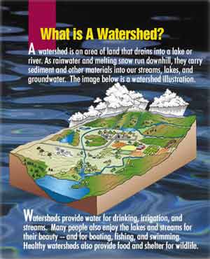
A watershed is a distinct area of land that "sheds" water in to a common water body (i.e. a stream, river, lake or groundwater reservoir). It is the topography of land that determines where a watershed's boundaries lie. Basically, water falls from the sky as precipitation (rain, snow, sleet, etc.) and is pulled downward by the force of gravity. You never see water flowing uphill, do you? Gravity pulls water downward to the lowest elevation or topographical level, thus forming streams and rivers in valleys as opposed to mountaintops. Those streams and rivers carry water to lower and lower elevations, running in to ponds, lakes and sometimes groundwater, and eventually empty in to the ocean. The total land area that water emptying in to a common set of waterways covers (from ridge to ridge) is called a watershed.
 |
|
Watersheds are important land distinctions for ecologists. For example, it is useful to know how and where water travels through land systems when studying environmental pollution and its effects; for determining water availability for growing human populations; for studying water quality over large geographic areas; and when thinking about best conservation practices and land management policies.
Other Online Watershed Resources:
• Know Your Watershed
• "Educating Young People About Water" Curriculum Database
• EPA Water Curriculum Links
2. As a class, identify the closest body of water (stream, estuary, reservoir, etc.) to your school. The class will map this water body, follow the water "upstream" to its source as precipitation, and then follow it further "downstream" until it flows in to a major waterway (or ocean, if close enough).
It is ideal for the class to actually visit the local water body that you will be mapping.
Before you go:
• Have students watch "The Invisible Creek" and download the map that a group of students made of Newtown Creek in New York City
• Have several maps for students to look at (other Green Maps downloadable at greenmap.com, topographical maps or aerial photographs of your local area available at usgs.gov, etc.) Make sure that at least one of the maps that they study is a topographical map, depicting relative elevations of landforms. (Check out earthview.sdsu.edu for more information on topographical maps, how to read them and how they are formed.)
• Facilitate a class exploration of the various maps and have students determine why each map is set up as it is, what the main features of each map are, and the specific purpose of each map.
• This should lead in to a discussion of their mapping project of your local water body. Have students determine which features of their local water body they want to highlight. What is the purpose of their map? Who is their map's audience?
Day Two (field trip):
3. Have students use base maps (topographical maps, street maps, aerial photographs, etc…), then add points of particular interest to your study. You may want each student to focus on a different aspect of the water body (i.e. access points, beautiful viewpoints, pollution hotspots, boat launches, wildlife hot spots, etc.), or you may want to have the entire class focus on the same aspect (i.e. an in-depth study of aquatic invertebrates and how their populations vary according to location in the water body). Be sure that each student contributes to the mapping process.
If the water body is close enough to your school, include the school in your map and the route taken by your class to get there. Include any businesses, parks, open spaces, industries, or anything else that is of interest to your study.
Day Three:
4. Once back in the classroom, have students finalize their map(s) and discuss what they learned. Is the water body a place they have been to before? If so, do they go there often? What did they find there? Was the water "clean?" How do they know that – what evidence exists that may give clues to the health of the water body? Did they see any wildlife in or around the water? If so, what? Would they go back there with family or friends? What other activities might they do if they visited the water body again?
5. Looking at regional topographical maps that include as many waterways as possible, determine where the water in the water body that you studied comes from. Determine where the ultimate source of the water is. How many miles from your water body is it? Where is it located in relation to your water body (i.e. to the north, south, etc.)? Which direction does the water flow? Then follow the water from your water body until it reaches a major waterway (large river, estuary, or ocean). Determine how many miles the water travels from point of precipitation to downstream outflow.
6. Learn your "watershed address" and view your watershed profile.
7. Based on your watershed profile, facilitate a class discussion about the various activities that take place in your watershed (i.e. agriculture, ranching, mining, residential developments, urban settings, parks, recreation, fishing, protected lands, etc.). How do these activities impact the overall health of the watershed? Which activities contribute positively and which negatively? How could students engage in activities that have a positive impact on the watershed?
ASSESSMENT SUGGESTIONS
• Map
• Presentation about mapping process and local water body
• Participation in discussion about your watershed
EXTENSION IDEAS
• Use special, internationally recognized "Green Map icons" to create a Green Map(s) as part of this project. Register your project and get support.
• Organize a map exposition for your grade/school/community that encourages students to teach others the significance of their local water body, the issues that may be attached to it, and what people can do to preserve it.
• Conduct water quality tests of the local water body. These may include dissolved oxygen, pH, salinity, temperature, turbidity, macro-invertebrate biodiversity, nitrate/nitrite, etc. Dissolved oxygen is a generally recognized indicator of water quality for both fresh and salt water. Acidity, or pH, is a common indicator for fresh water. Inexpensive testing equipment and kits can be obtained at many science suppliers, including Carolina Biological.
• The Watershed Game is a wonderful resource that allows students to make decisions regarding the management of their watershed.
RELATED NATIONAL SCIENCE EDUCATION STANDARDS FOR GRADES 9-12
Science Standards
Science as Inquiry
• Abilities necessary to do scientific inquiry
• Understanding about scientific inquiry Physical Science
• Motions and Forces
Earth and Space Science
• Energy in the Earth system
• Geochemical cycles
Science and Technology
• Abilities of technological design
• Understandings about science and technology
Science in Personal and Social Perspective
• Personal and community health
• Natural resources
• Environmental quality
• Natural and Human-induced hazards
• Science and technology in local, national and global challenges
Geography Standards (McREL)
The World in Spatial Terms
• Understands the characteristics and uses of maps, globes and other geographic tools and technologies
Places and Regions
• Understands the physical and human characteristics of place
• Understands the concept of regions
Physical Systems
• Knows the physical processes that shape patterns on earth's surface
Environment and Society
• Understands how physical systems affect human systems
INTERNET RESOURCES FOR TEACHERS AND STUDENTS
United States Geological Survey: Water Science for Schools
Includes water use questions for students, glossary of water terms, water basics, maps and water use statistical data.
United States Environmental Protection Agency
Includes information on water pollutants, drinking water, water quality monitoring, and many other related topics. Includes an alphabetical list of all topics contained on the site.
Natural Resources Defense Council
Includes information and articles on drinking water, water conservation and restoration and more.
Maptech.com
Use USGS maps to create/save/print "My Map" with your own icons. Database of maps includes entire United States.
Topozone.com
Free, downloadable topographical maps for the entire U.S.
RELATED PBS RESOURCES
Africa: Eco Challenges
Address two pressing issues confronting continental Africa — the growing
desertification
and the scarcity of clean water — within the context of Africa's development
and
the environmental, economic, and personal impact it has upon its citizens.
American Field Guide: Floods
In this lesson, students will look at factors of severe flooding, such as deforestation
and development. Students will use a stream table to experiment with water
flow and observe processes related to flooding.
Global Connections: Got Water?
Students will learn that delivering clean, fresh water to citizens around the world involves and affects politics, economics, international relations, and technology.
Journey to Planet Earth: Rivers of Destiny
Learn how human activity has altered the natural course and condition of three
famous rivers: the Mekong, the Amazon, and the Mississippi.
Journey
to Planet Earth: Water, Water Everywhere — Is it Safe?
Students explore the contents of untreated water, using a microscope to find
organisms, create their own filtering system to clean the water, and research
water-borne pathogens that may be increasing in number due to effects of global
warming.
The West: Water Use: Tragedy in the Owens River Valley
Learn about watersheds, ground water and aquifers and examine controversial water-use
policies through a historical case study of the Owens River Valley, where water
was dammed and diverted to residents of Los Angeles.
POV's
Classroom
POV documentaries are a valuable resource for teachers and students. Use
these companion lesson plans to present POV films to your class.
PBS
Teachersource
PBS showcases the work of hundreds of diverse producers and local PBS stations,
who in turn tap the creative minds of top thinkers from around the world to
create education's best content.
|